
Annapurna Base Camp (ABC) Trek
Trip Introduction
The Annapurna Base Camp (ABC) Trek is one of Nepal’s most popular and rewarding trekking experiences. It offers stunning Himalayan views, diverse landscapes, and rich cultural encounters—all within a relatively moderate trekking distance and altitude. Here’s a comprehensive overview to help you plan or understand the trek: Highlights of Annapurna Base Camp (ABC) Trek
- Panoramic Views of Annapurna I (8,091 m), Machapuchare (Fishtail), Hiunchuli, and more
- Annapurna Sanctuary: A natural amphitheater of giant Himalayan peaks
- Cultural Insight: Gurung and Magar villages with warm hospitality
- Hot Springs: Relax in the natural hot springs at Jhinu Danda
- Diverse Landscapes: Rice terraces, bamboo forests, alpine meadows
Annapurna Base Camp (ABC) Trek Package Cost
Standard 10-Days Package Cost: $ 770 per person with Private Reserve Transport (Pokhara to Ulleri and Jhinu to Pokhara)
Standard 10-Days Package Cost:$ 728 per person with Local Transport (Pokhara to Ulleri and Jhinu to Pokhara)
Includes food Package :
 Airport Pickup and Drop, All the Transportation accommodation during the trek,
full board meals, breakfast , lunch, dinner ,Tea, Coffee, during the treks
All necessary permits , ACP, Annapurna base camp trek,
one English speaking Government certificate holder trekking guide
Two trekkers between one porter they will carry around 2o to 25 kg)
Fingertip pulse Oximeter (we use every day to check your oxygen level and pulse in your body to avoid high risk.)
Guide and porter: food, lodge, transportation, salary, insurance, equipment etc.
13% Government Vat and official expenses.
Best available Room and Lodge during the treks.
Bal Hiking Team provide Duffel Bag packing your equipment during the treks
Sleeping bag down Jacket for use during the treks , after you will be refund for Agency ( if you requirement)
Trekking Certificates, Staffs first aid kid,
Seasonal fresh fruits and Biscuits etc.
From pokhara to Nayapool- Tikhedunga – Ulleri by provide car or jeep-Public Bus and Jinu Dada – kyume –Nayapool by Car or Jeep – Public Bus to pokhara
Excludes package :
 Coke , Fanta, beer , Whiskey , better changing , wifi, hot shower, water ect.
You trekking gears Helicopter, Trekking Equipment
Transport from kathamandu to pokhara by tourist bus or flight -car
International flights,
Hotel in Kathmandu, Pokhara Nepal visa, Travel insurance,
Guide /Porter trekking staff Tips personal expenses.
Annapurna Base Camp (ABC Trek) Itinerary 10 days
Day 1: Pokhara → Nayapul → Tikhedhunga/Ulleri
-Elevation gain: 1 030 m (Nayapul 1 070 m → Tikhedhunga 1 600 m) or 1 230 m (to Ulleri 1 960 m)
-Time (trekking): 4 – 5 hours to Tikhedhunga; +1 – 1.5 h to Ulleri
Overnight: Teahouse in Ulleri (depending on time/fitness).
Include: L/D/Tea and Coffee with accommodation
Day 2: Tikhedhunga/Ulleri → Ghorepani
Starting elevation:
-Ulleri: 1 960 m
-Ending elevation: Ghorepani (2 850 m)
Distance (trekking):
-From Ulleri → Ghorepani: ~16 km
Elevation gain:
-Ulleri → Ghorepani: +890 m
-Time: ~6–7 hours (Tikhedhunga) / 5–6 hours (Ulleri)
Route & highlights:
Pass through villages:Banthati, Nangi and Ghorapani Khola (depending on route), ending at Ghorepani (2 850 m).
Lodge options are plentiful; acclimatize with shorter walks around the village.
Overnight: Teahouse in Ghorepani.
Notes:Drink plenty of water and keep energy snacks handy.
Include: B/L/D/Tea and Coffee with accommodation
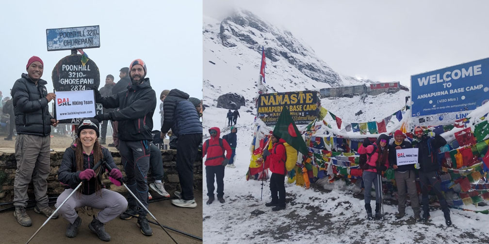
Day 3: Ghorepani → (Poon Hill sunrise) → Tadapani
Early morning (pre-dawn):
-Poon Hill (3 210 m) for sunrise view over Machhapuchhre, Dhaulagiri & Annapurna Himalayas.
-Round-trip: ~3 km (2 .5 – 3 h return to Ghorepani, including ~200 m ascent from village).
-Breakfast back in Ghorepani.
Trek: Ghorepani → Tadapani
Elevation change: 2 850 m → 2 630 m (net –220 m, but involves minor ascents/descents)
Distance: ~10 km
Time: 5 – 6 hours
Route & highlights:
-Descend from Ghorepani through rhododendron and oak forests to Ghorepani Khola.
-Climb gently to Deurali (~3 055 m)—small ridge and guesthouses (not to be confused with Deurali beyond ABC).
-Continue downhill, passing Tikiothan, Laba Kharka, Banthanti, and then ascend gently to Tadapani (2 630 m).
-Enjoy views of Annapurna South and Hiunchuli from Tadapani viewpoint near the village.
Overnight: Teahouse in Tadapani.
Include: B/L/D/Tea and Coffee with accommodation
Day 4: Tadapani → Chhomrong
-Starting elevation: 2 630 m
-Ending elevation: 2 170 m
-Distance: ~11 km
-Time: 5 – 6 hours
Route & highlights:
-From Tadapani, descend through dense rhododendron/oak forest along a steep, rocky trail to Gandruk Khola (~2 100 m).
-Cross suspension bridge over Chhomrong Khola and begin a long ascent (~850 m) toward Chhomrong Village (2 170 m).
-Chhomrong: one of the larger Gurung villages on the trail. Views of Annapurna South & Fishtail (Machhapuchhre).
Overnight: Teahouse in Chhomrong.
Notes:The uphill from Chhomrong Khola to Chhomrong is steep (stone steps for ~200 m elevation gain). You’ll begin to sense the Annapurna Sanctuary walls closing in.
Include: B/L/D/Tea and Coffee with accommodation
Day 5: Chhomrong → Dovan
-Starting elevation: 2 170 m
-Ending elevation: 2 600 m
-Distance: ~12 km
-Time: 5 – 6 hours
Route & highlights:
-Depart Chhomrong → steep descent (over 1 000 steps) to Chhomrong Khola (around 1 550 m).
-Cross the suspension bridge → ascend through bamboo forest to Sinuwa (2 340 m).
-Continue through forested trail, passing Hinku Cave (2 520 m) and Jhinudanda (2 630 m) (not to be confused with Jhinu hot springs near the end).
-Arrive at Dovan (2 600 m)—small cluster of lodges set alongside a waterfall-fed stream.
Overnight: Teahouse in Dovan.
Notes:Waterfalls near Dovan offer great photo opportunities. Expect moderate uphill sections after Sinuwa.
Include: B/L/D/Tea and Coffee with accommodation
Day 6: Dovan → Deurali
-Starting elevation: 2 600 m
-Ending elevation: 3 230 m
-Distance: ~10 km
-Time: 5 – 6 hours
Route & highlights:
-From Dovan, follow a gradual uphill through thick bamboo and rhododendron forest.
-Pass Bamboo (2 310 m)—a good mid-point for lunch/rest.
-Continue through bamboo to Himalaya Hotel (2 900 m)—a small lodge spot.
-A short, steeper ascent from there brings you to Deurali (3 230 m)—gateway to the Annapurna Sanctuary proper.
-Deurali has one of the last teahouses with heated rooms (if requested in advance).
-Overnight: Teahouse in Deurali.
Notes: Above Bamboo, trails can be steep and rocky, so trekking poles are helpful. Keep an eye out for blue sheep and, if lucky, Himalayan Thar.
Include: B/L/D/Tea and Coffee with accommodation
Day 7: Deurali → Annapurna Base Camp (via Machhapuchhre Base Camp)
-Starting elevation: 3 230 m
-High point en route: Machhapuchhre Base Camp (MBC) ~3 700 m
-Destination elevation: Annapurna Base Camp (4 130 m)
-Distance: ~8 km one way
-Time: 6 – 7 hours to ABC (one direction)
Route & highlights:
-From Deurali, follow signs to MBC (Machhapuchhre Base Camp)—a rocky, moraine-lined trail.
-MBC (3 700 m) offers sweeping views of Machhapuchhre’s south face and Mardi Himal.
-Continue along moraines to Machhapuchhre Base Camp Viewpoint (3 900 m)—cross small streams.
-Final ascent through rocky boulder-strewn path to Annapurna Base Camp (4 130 m).
-Surrounded by towering peaks: Annapurna I (8 091 m), Annapurna South (7 219 m), Hiunchuli (6 441 m), Gangapurna (7 455 m).
-Snow-fed glacier streams, prayer flags everywhere—this is the sanctuary’s heart.
Overnight: Teahouse in ABC.
Notes: Weather can be unpredictable above 3 500 m; cold, windy—carry warm down layers and gloves. Spend time taking photographs and resting; avoid strenuous activity for acclimatization. It’s common to arrive mid-afternoon (2–4 pm)—ample daylight for trial acclimatization.
Include: B/L/D/Tea and Coffee with accommodation
Day 8: ABC → Bamboo (descent start)
-Starting elevation: 4 130 m
-Ending elevation: 2 310 m
-Distance: ~24 km (via Deurali + Dovan → Bamboo)
-Time: 8 – 9 hours (long descent day)
Route & highlights:
-Early departure from ABC (around 6–7 am) for the long downhill.
-Retrace steps: ABC → MBC → Deurali (3 230 m) (2–3 h)
-Deurali → Bamboo (2 310 m) via Dovan (2 600 m) (additional 4–5 h)
-Bamboo (2 310 m): lush valley, occasional farmsteads. Good spot to relax after several days above 3 000 m.
Overnight: Teahouse in Bamboo.
Notes: Descending from high altitude can strain knees; use trekking poles and take frequent breaks. If you’d rather split this day, consider stopping at Dovan for the night and reaching Bamboo.
Include: B/L/D/Tea and Coffee with accommodation
Day 9: Bamboo → Jhinu Danda (Hot Springs)
-Starting elevation: 2 310 m
-Ending elevation: 1 780 m
-Distance: ~11 km
-Time: 4 – 5 hours
Route & highlights:
-From Bamboo, follow the trail downhill through rhododendron and bamboo forest.
-Pass Sinuwa (2 340 m) (if using an alternative descent route), then continue steeply down to Jhinu Danda (1 780 m).
-Jhinu Danda: famous for its hot springs (Ghiling or Jhinu hot springs) situated ~15 minutes downstream.
-Many trekkers soak their sore muscles in the natural 40 – 45 °C pools.
Overnight: Teahouse in Jhinu Danda.
Notes: There is a small entry fee (~100 NPR) for the hot springs. If you’re tired, spend additional time at the hot springs to relax before descending further.
Include: B/L/D/Tea and Coffee with accommodation
Day 10: Jhinu Danda → Nayapul → Pokhara
-Starting elevation: 1 780 m
-Ending elevation: 820 m (Pokhara)
-Distance (trekking): ~7 km (Jhinu → Nayapul)
-Time (trekking): ~2 – 3 hours (mostly downhill/flat)
Additional travel:
Nayapul → Pokhara: ~45 km by jeep/van → 1–1.5 hours
Route & highlights:
Jhinu → Nayapul: Follow a well-marked trail along Modi Khola River. Gentle downhill/flat sections interspersed with occasional uphill patches.
-Arrive in Pokhara by early afternoon—time to rest, shower, and celebrate your trek!
–If you finish early, you can opt to visit Lakeside Pokhara, go boating on Phewa Lake, or explore the old bazaar.
Include: B/L/Tea and Coffee
Annapurna Base Camp (ABC) Trek Equipment Lists
Clothing
Base Layers
- Thermal Tops (1–2)
Lightweight, moisture-wicking merino wool or synthetic (e.g., Patagonia Capilene, Icebreaker). - Thermal Bottoms (1–2)
Same material as above; provides warmth at higher altitudes.
Mid Layers
- Fleece Jacket or Pullover (1)
200–300 gsm fleece; full-zip preferred for ventilation (e.g., The North Face Denali, Patagonia R1). - Insulating Jacket (1)
Lightweight down- or synthetic-filled jacket (e.g., Rab Microlight Alpine, MontBell Down Inner Parka). - Softshell (optional)
Breathable softshell pant and/or jacket if you expect wind/rain, though most seasons a waterproof shell suffices.
Outer Shell
- Waterproof/Windproof Jacket (1)
3-layer hardshell rain jacket with taped seams (e.g., Arc’teryx Beta, Marmot PreCip). - Waterproof Pants (1)
Lightweight rain pants (can be worn over trekking pants on rainy days).
Trekking Pants & Shorts
- Trekking Pants (1–2)
Lightweight, quick-dry nylon or nylon-spandex blend (e.g., Columbia Silver Ridge, PrAna Stretch Zion). Convertible zip-offs are handy for changing temperatures. - Trekking Shorts (1)
For lower-altitude or midday warmth.
Shirts
- Moisture-Wicking T-Shirts (2–3)
Synthetic or merino (e.g., Smartwool, Icebreaker). - Long-Sleeve Shirt (1)
Can double as sun protection; lightweight.
Insulated Jacket for Summit Nights
- Heavyweight Down Jacket (1)
Rated to at least -10 °C/14 °F (you’ll be >4,000 m). If your “insulating jacket” above is thick enough, you may get by with it; otherwise bring a separate mid-weight down parka.
Underwear & Socks
- Underwear (3–4 pairs)
Quick-dry synthetic or merino. - Trekking Socks (3–4 pairs)
Merino or synthetic blend; avoid 100 % cotton. - Lightweight Liner Socks (1–2 pairs, optional)
Helps prevent blisters if you have sensitive feet. - Warm Socks (1 pair)
Thick wool or synthetic for cold nights.
Footwear
- Trekking Boots
Sturdy, waterproof, broken‐in mid- or high-cut boots (e.g., Salomon Quest 4D, Lowa Renegade). Make sure they’re well broken in at least 2–3 weeks before departure. - Camp Shoes/Sandals
Lightweight flip-flops or closed-toe sandals (e.g., Teva, Crocs) to give your feet a rest in teahouses. - Gaiters (optional)
Lightweight gaiters to keep snow or scree/dust out of boots when above 4,000 m, especially if hiking early or late in season.
Backpack & Packing
- Main Trekking Backpack (50–60 L)
Adjustable harness, padded hip belt, rain cover (often built in). - Daypack/Day Sack (20–30 L)
For summit day (carry water, snacks, camera, extra layers). - Dry Bags/Stuff Sacks
1–2 large for clothes; 1–2 small for electronics / valuables. - Pack Rain Cover
If not built into backpack, get a separate one.
Sleeping Gear
- Sleeping Bag
Rated to at least -10 °C (14 °F). We recommend a down bag in a mummy cut (e.g., Marmot Helium, North Face Cat’s Meow). - Sleeping Bag Liner (optional)
Increases warmth by 5–7 °C (9–13 °F) and keeps your bag cleaner. Silk or lightweight fleece liners both work. - Travel Pillow (optional)
Inflatable or compressible microfiber pillow.
Trekking Accessories
- Trekking Poles (1 pair)
Adjustable, lightweight aluminum/carbon (e.g., Black Diamond), with snow baskets if trekking in late fall or spring conditions. - Headlamp + Extra Batteries
Compact LED headlamp (e.g., Petzl Actik) with at least two spare AA/AAA batteries. - Sunglasses
Category 4/high UV protection goggles for snowy/bright conditions. - Sun Hat/Cap
Wide-brim or baseball cap with UV protection. - Buff/Neck Gaiter
Multipurpose for wind, dust, or warmth. - Warm Hat/Beanie
Fleece or wool for mornings and evenings. - Gloves
Lightweight liner gloves for daytime
• Insulated waterproof gloves or mittens for summit and cold nights.
Hydration & Nutrition
- Water Bottles (1–2 × 1 L)
Insulated stainless steel or Nalgene; prevents water from freezing above 3,000 m. - Hydration Reservoir (optional)
If you prefer a 2–3 L CamelBak-style bladder; note that tubes can freeze. - Water PurificationPurification tablets (e.g., Aquatab) — lightweight and reliabl,OR inline filter (e.g., Sawyer Mini, Katadyn BeFree)
- Snacks/Energy Bars
Bring a handful of your favorites (e.g., Clif Bars, Trek’n Eat) for extra calories on long days.
First Aid & Personal Care
- Personal First Aid Kit (in a small zip-lock):
Blister plasters (Compeed, Leukotape + moleskin)
• Band-Aids of various sizes
• Painkillers (ibuprofen/acetaminophen)
• Diamox (acetazolamide) if you plan to use medication for altitude sickness (consult a doctor)
• Personal prescription meds (plus copies of prescriptions)
• Hand sanitizer (travel size)
• Wet wipes (biodegradable if possible) - Toiletries
Toothbrush, toothpaste
• Biodegradable soap/shampoo — many teahouses provide hot-water baths for a fee
• Quick-dry travel towel (microfiber)
• Sunscreen (SPF 30+) & lip balm (SPF 30+)
• Small travel roll of toilet paper (some teahouses may not stock it) - Hand Warmers (1–2 pairs)
Disposable chemical warmers for summit day.
Electronics & Navigation
- Mobile Phone + Portable Power Bank
10,000 mAh+ power bank (so you can charge at least 2–3 times)
• Nepalese SIM card (Ncell or NTC) if you want local coverage (can buy in Kathmandu/Pokhara; note: network gets spotty above 3,500 m) - Camera (optional)
Lightweight mirrorless or compact (remember extra batteries; cold drains them faster). - GPS/Offline Maps
Download maps on apps like Maps.me or Gaia GPS before departure. - Travel Adapter
Nepal uses Type D (and sometimes C) plugs; voltage is 230 V 50 Hz.
Documents & Money
- Passport + Photocopies
Keep 2–3 photocopies in separate pockets. - Trekking Permits
TIMS Card (Trekkers’ Information Management System) — get in Kathmandu before trekking
• Annapurna Conservation Area Permit (ACAP) — can also be obtained in Pokhara or at entry points - Cash (Nepalese Rupees)
Teahouses only accept cash. ATMs exist in Pokhara, Chhomrong, etc., but very limited. Bring at least NPR amount for an emergencies. - Credit/Debit Cards
Most teahouses do NOT accept cards. Some lodges in Pokhara or big hotels in Kathmandu do, but don’t rely on them above 2,500 m.
Optional Extras
- Lightweight Sitting Pad
Foam or inflatable pad for teahouse benches. - Trekking Journal & Pen
For notes or journaling along the way. - Book/E-Reader
Something light for rest days. - Gaiters
If trekking in dusty conditions or crossing snow. - Camera Tripod (mini)
If you want stable landscape shots at ABC. - Solar Charger Panel (optional)
Very slow at high altitudes; usually a power bank + charging in teahouses (for a small fee) is sufficient.
Seasonal Considerations
- Spring (March–May)
Nights can still drop near freezing at low elevations; warm layers still needed.
• Trails may be crowded; gear shops in Pokhara/Kathmandu well stocked. - Monsoon (June–August)
Heavy rain; you’ll need a more robust rain jacket/pants, quick-dry clothing, and gaiters.
• Leech socks if you expect leeches below 2,500 m. - Autumn (September–November)
Peak season; cold nights get below -5 °C at 4,000 m.
• Strong UV higher up—make sure to carry good sunglasses and sunscreen. - Winter (December–February)
Snow possible above 3,000 m; bring warmer down jacket (-20 °C rating), ski goggles (snow can be blinding), and maybe microspikes/crampons for ice.
• Many tea houses close in dead of winter; check current conditions/availability.
Where to Buy or Rent in Kathmandu/Pokhara
Kathmandu (Thamel Area)
- Himalayan Rescue Association (HRA)
Good source of information and sometimes gear. - Mountain Hardwear, Sherpa Adventure Gear, The North Face outlets
Locally manufactured Sherpa Adventure Gear often costs less than imported brands. - Rental Shops (e.g., Putha Hiunchuli Sports, Base Camp Trekking Equipment Rental)
Rent: sleeping bags, down jackets, sleeping mats, trekking poles, crampons, microspikes, gaiters. Daily/weekly rates are reasonable (approx. NPR 100–300/day per item).
Pokhara
- Pokhara Adventure Gear Shop
Rent or buy last-minute gear. - Saipal Sports, Sherpa World, Spread Eagle Adventure Gear
More selection of international brands; rent or buy—you can find good deals on last-year’s models.
Tip: If you’re traveling light, you can buy cheaper gear in Kathmandu/Pokhara (e.g., synthetic down jackets, mid-layers), then donate or leave behind at the end of your trek (many teahouses accept donations). However, for items like trekking boots and sleeping bags, it’s often better to bring your own quality gear.
Packing Tips & Weight Management
- Target Base Weight (everything except consumables – food, water, camera batteries) at around 8–10 kg (≈ 18–22 lb). With food and water, your trail weight may reach 12–13 kg (≈ 26–29 lb).
- Roll Clothing to save space.
- Use Dry Bags to compress bulky down items.
- Minimize Duplicates (e.g., one multipurpose mid-layer rather than two jackets).
- Test-Fit Your Pack at home: fill it with gear and water, walk around to ensure it’s comfortable and balanced.
- Label Gear with contact info; porters sometimes mix bags if they look alike.
Final Reminders
- Break In Your Boots Early: Aim for at least 2 weeks of walking/hiking in your trekking boots to avoid blisters.
- Layer, Layer, Layer: Temperature can swing from 20 °C (68 °F) at Ghorepani (2,850 m) to −10 °C (14 °F) at ABC (4,130 m) early mornings—adjust layers frequently.
- Hydration & Altitude: Drink at least 3–4 L of water per day as you ascend. Consider carrying powdered electrolyte tablets.
- Pack Light, Pack Smart: Every extra kilogram feels heavier above 3,000 m. Reevaluate each item: “Will I really need this?”
- Check Weather Forecast: Before departure, review a reliable mountain forecast (e.g., Mountain-Forecast.com for ABC) to know if you’ll need microspikes, gaiters, or extra insulation.
- Permit Copies: Keep photocopies of TIMS and ACAP in a waterproof bag; tea-house staff will check them each morning.
- Insurance: Make sure your travel insurance covers high-altitude trekking and helicopter evacuation (up to 5,500 m).
Detail Itenerary
-
Annapurna Base Camp (ABC Trek) Itinerary 10 days
Day 1: Pokhara → Nayapul → Tikhedhunga/Ulleri
-Elevation gain: 1 030 m (Nayapul 1 070 m → Tikhedhunga 1 600 m) or 1 230 m (to Ulleri 1 960 m)
-Time (trekking): 4 – 5 hours to Tikhedhunga; +1 – 1.5 h to Ulleri
Overnight: Teahouse in Ulleri (depending on time/fitness).
Include: L/D/Tea and Coffee with accommodation
Day 2: Tikhedhunga/Ulleri → Ghorepani
Starting elevation:
-Ulleri: 1 960 m
-Ending elevation: Ghorepani (2 850 m)
Distance (trekking):
-From Ulleri → Ghorepani: ~16 km
Elevation gain:
-Ulleri → Ghorepani: +890 m
-Time: ~6–7 hours (Tikhedhunga) / 5–6 hours (Ulleri)
Route & highlights:
Pass through villages:Banthati, Nangi and Ghorapani Khola (depending on route), ending at Ghorepani (2 850 m).
Lodge options are plentiful; acclimatize with shorter walks around the village.
Overnight: Teahouse in Ghorepani.
Notes:Drink plenty of water and keep energy snacks handy.
Include: B/L/D/Tea and Coffee with accommodation
Day 3: Ghorepani → (Poon Hill sunrise) → Tadapani
Early morning (pre-dawn):
-Poon Hill (3 210 m) for sunrise view over Machhapuchhre, Dhaulagiri & Annapurna Himalayas.
-Round-trip: ~3 km (2 .5 – 3 h return to Ghorepani, including ~200 m ascent from village).
-Breakfast back in Ghorepani.
Trek: Ghorepani → Tadapani
Elevation change: 2 850 m → 2 630 m (net –220 m, but involves minor ascents/descents)
Distance: ~10 km
Time: 5 – 6 hours
Route & highlights:
-Descend from Ghorepani through rhododendron and oak forests to Ghorepani Khola.
-Climb gently to Deurali (~3 055 m)—small ridge and guesthouses (not to be confused with Deurali beyond ABC).
-Continue downhill, passing Tikiothan, Laba Kharka, Banthanti, and then ascend gently to Tadapani (2 630 m).
-Enjoy views of Annapurna South and Hiunchuli from Tadapani viewpoint near the village.
Overnight: Teahouse in Tadapani.
Include: B/L/D/Tea and Coffee with accommodation
Day 4: Tadapani → Chhomrong
-Starting elevation: 2 630 m
-Ending elevation: 2 170 m
-Distance: ~11 km
-Time: 5 – 6 hours
Route & highlights:
-From Tadapani, descend through dense rhododendron/oak forest along a steep, rocky trail to Gandruk Khola (~2 100 m).
-Cross suspension bridge over Chhomrong Khola and begin a long ascent (~850 m) toward Chhomrong Village (2 170 m).
-Chhomrong: one of the larger Gurung villages on the trail. Views of Annapurna South & Fishtail (Machhapuchhre).
Overnight: Teahouse in Chhomrong.
Notes:The uphill from Chhomrong Khola to Chhomrong is steep (stone steps for ~200 m elevation gain). You’ll begin to sense the Annapurna Sanctuary walls closing in.
Include: B/L/D/Tea and Coffee with accommodation
Day 5: Chhomrong → Dovan
-Starting elevation: 2 170 m
-Ending elevation: 2 600 m
-Distance: ~12 km
-Time: 5 – 6 hours
Route & highlights:
-Depart Chhomrong → steep descent (over 1 000 steps) to Chhomrong Khola (around 1 550 m).
-Cross the suspension bridge → ascend through bamboo forest to Sinuwa (2 340 m).
-Continue through forested trail, passing Hinku Cave (2 520 m) and Jhinudanda (2 630 m) (not to be confused with Jhinu hot springs near the end).
-Arrive at Dovan (2 600 m)—small cluster of lodges set alongside a waterfall-fed stream.
Overnight: Teahouse in Dovan.
Notes:Waterfalls near Dovan offer great photo opportunities. Expect moderate uphill sections after Sinuwa.
Include: B/L/D/Tea and Coffee with accommodation
Day 6: Dovan → Deurali
-Starting elevation: 2 600 m
-Ending elevation: 3 230 m
-Distance: ~10 km
-Time: 5 – 6 hours
Route & highlights:
-From Dovan, follow a gradual uphill through thick bamboo and rhododendron forest.
-Pass Bamboo (2 310 m)—a good mid-point for lunch/rest.
-Continue through bamboo to Himalaya Hotel (2 900 m)—a small lodge spot.
-A short, steeper ascent from there brings you to Deurali (3 230 m)—gateway to the Annapurna Sanctuary proper.
-Deurali has one of the last teahouses with heated rooms (if requested in advance).
-Overnight: Teahouse in Deurali.
Notes: Above Bamboo, trails can be steep and rocky, so trekking poles are helpful. Keep an eye out for blue sheep and, if lucky, Himalayan Thar.
Include: B/L/D/Tea and Coffee with accommodation
Day 7: Deurali → Annapurna Base Camp (via Machhapuchhre Base Camp)
-Starting elevation: 3 230 m
-High point en route: Machhapuchhre Base Camp (MBC) ~3 700 m
-Destination elevation: Annapurna Base Camp (4 130 m)
-Distance: ~8 km one way
-Time: 6 – 7 hours to ABC (one direction)
Route & highlights:
-From Deurali, follow signs to MBC (Machhapuchhre Base Camp)—a rocky, moraine-lined trail.
-MBC (3 700 m) offers sweeping views of Machhapuchhre’s south face and Mardi Himal.
-Continue along moraines to Machhapuchhre Base Camp Viewpoint (3 900 m)—cross small streams.
-Final ascent through rocky boulder-strewn path to Annapurna Base Camp (4 130 m).
-Surrounded by towering peaks: Annapurna I (8 091 m), Annapurna South (7 219 m), Hiunchuli (6 441 m), Gangapurna (7 455 m).
-Snow-fed glacier streams, prayer flags everywhere—this is the sanctuary’s heart.
Overnight: Teahouse in ABC.
Notes: Weather can be unpredictable above 3 500 m; cold, windy—carry warm down layers and gloves. Spend time taking photographs and resting; avoid strenuous activity for acclimatization. It’s common to arrive mid-afternoon (2–4 pm)—ample daylight for trial acclimatization.
Include: B/L/D/Tea and Coffee with accommodation
Day 8: ABC → Bamboo (descent start)
-Starting elevation: 4 130 m
-Ending elevation: 2 310 m
-Distance: ~24 km (via Deurali + Dovan → Bamboo)
-Time: 8 – 9 hours (long descent day)
Route & highlights:
-Early departure from ABC (around 6–7 am) for the long downhill.
-Retrace steps: ABC → MBC → Deurali (3 230 m) (2–3 h)
-Deurali → Bamboo (2 310 m) via Dovan (2 600 m) (additional 4–5 h)
-Bamboo (2 310 m): lush valley, occasional farmsteads. Good spot to relax after several days above 3 000 m.
Overnight: Teahouse in Bamboo.
Notes: Descending from high altitude can strain knees; use trekking poles and take frequent breaks. If you’d rather split this day, consider stopping at Dovan for the night and reaching Bamboo.
Include: B/L/D/Tea and Coffee with accommodation
Day 9: Bamboo → Jhinu Danda (Hot Springs)
-Starting elevation: 2 310 m
-Ending elevation: 1 780 m
-Distance: ~11 km
-Time: 4 – 5 hours
Route & highlights:
-From Bamboo, follow the trail downhill through rhododendron and bamboo forest.
-Pass Sinuwa (2 340 m) (if using an alternative descent route), then continue steeply down to Jhinu Danda (1 780 m).
-Jhinu Danda: famous for its hot springs (Ghiling or Jhinu hot springs) situated ~15 minutes downstream.
-Many trekkers soak their sore muscles in the natural 40 – 45 °C pools.
Overnight: Teahouse in Jhinu Danda.
Notes: There is a small entry fee (~100 NPR) for the hot springs. If you’re tired, spend additional time at the hot springs to relax before descending further.
Include: B/L/D/Tea and Coffee with accommodation
Day 10: Jhinu Danda → Nayapul → Pokhara
-Starting elevation: 1 780 m
-Ending elevation: 820 m (Pokhara)
-Distance (trekking): ~7 km (Jhinu → Nayapul)
-Time (trekking): ~2 – 3 hours (mostly downhill/flat)
Additional travel:
Nayapul → Pokhara: ~45 km by jeep/van → 1–1.5 hours
Route & highlights:
Jhinu → Nayapul: Follow a well-marked trail along Modi Khola River. Gentle downhill/flat sections interspersed with occasional uphill patches.
-Arrive in Pokhara by early afternoon—time to rest, shower, and celebrate your trek!
–If you finish early, you can opt to visit Lakeside Pokhara, go boating on Phewa Lake, or explore the old bazaar.
Include: B/L/Tea and Coffee
Array
Included in the Cost
Includes food package :
Airport Pickup and Drop, All the Transportation accommodation during the trek,
full board meals, breakfast , lunch, dinner ,Tea, Coffee, during the treks
All necessary permits , ACP, Annapurna base camp trek,
one English speaking Government certificate holder trekking guide
Two trekkers between one porter they will carry around 2o to 25 kg)
Fingertip pulse oximeter (we use every day to check your oxygen level and pulse in your body to avoid high risk.)
Guide and porter: food, lodge, transportation, salary, insurance, equipment etc.
13% Government Vat and official expenses.
Best available Room and Lodge during the treks.
Bal Hiking Team provide Duffel Bag packing your equipment during the treks
Sleeping bag down Jacket for use during the treks , after you will be refund for Agency ( if you requirement)
Trekking Certificates, Staffs first aid kid,
Seasonal fresh fruits and Biscuits etc.
From pokhara to Nayapool- Tikhedunga – Ulleri by provide car or jeep-Public Bus and Jinu Dada – kyume –Nayapool by Car or Jeep – Public Bus to pokhara
Excludes package :
Coke , Fanta, beer , Whiskey , better changing , wifi, hot shower, water ect.
You trekking gears Helicopter, Trekking Equipment
Transport from kathamandu to pokhara by tourist bus or flight -car
International flights,
Hotel in Kathmandu, Pokhara Nepal visa, Travel insurance,
Guide /Porter trekking staff Tips personal expenses.
1 Reviews on Annapurna Base Camp (ABC) Trek View All
Leave a Reply
-
All Inclusive Price 728 $
-
Duration 10 days $ 728
Customer Review
1 reviews
 Makalu Base Camp Trek cost with Guide and Porter 30-35$
16 days $1988
 Annapurna Base Camp (ABC) Trek
10 days $ 728
 Everest Three Passes Trek
18-19 Day $ 1700
 Everest Base Camp (EBC) Trek
14 Days $ 985
- Location : Annapurna base camp treks
- Duration : 10 days $ 728
- Trek Grade : Easy
- Max Elevation : 4130 m
- Trek Style : Lodge
- Mode of Trek : lodges / Tea house treks
Quick Inquiry
Related Packages
-
Duration:21 days $ 2338
Trip Grade: Moderate
Max. Altitude
5`143 m
-
Duration:20 Day $1560
Trip Grade: Moderate
Max. Altitude
5106 m
-
Duration:14 day $ 706
Trip Grade: Moderate
Max. Altitude
5106 m
-
Duration:14 Days $ 985
Trip Grade: Moderate
Max. Altitude
5550 m

2025-06-10 03:09:54
Kitti Tenerife, Spain, says:
Perfect ABC trek I choose Bal Hiking Team , and want go solo traveler but we had a small group with two other kind people, our guide Bal and our two porters Lochan and Robin. I want to name them because they really did an amazing job, always...