
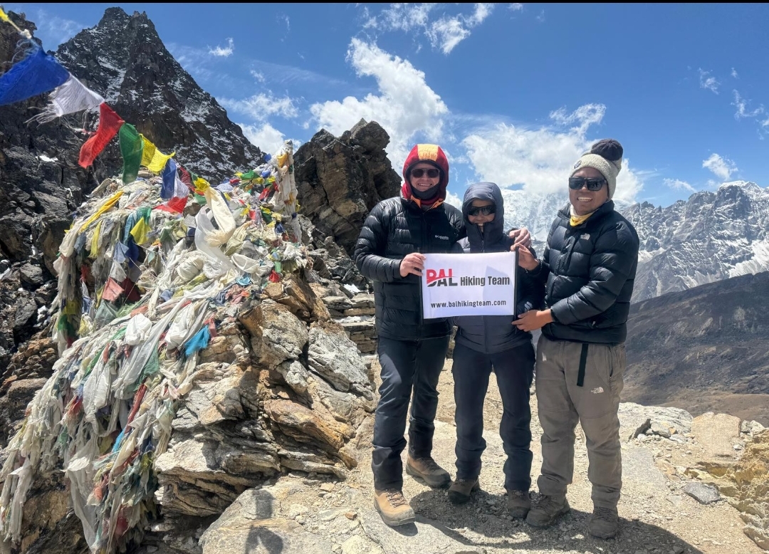
Everest Three Passes Trek
Trip Introduction
The Everest Three Passes Trek is a challenging, high-altitude circuit in Nepal’s Sagarmatha (Everest) region that links three major Himalayan passes—Renjo La, Cho La, and Kongma La—into a single loop. Rather than a straightforward ascent to Everest Base Camp (EBC), this trek combines multiple routes (the Gokyo Lakes trail, the traditional EBC trail, and the path over three high passes) to offer exceptionally diverse scenery: alpine lakes, suspension bridges, Sherpa villages, and panoramic views of some of the world’s highest peaks (including Everest, Lhotse, Cho Oyu, Makalu, and countless others).
Typically lasting 18–20 days, the trek begins (and ends) with a flight into Lukla (2,860 m) and navigates through key settlements such as Namche Bazaar, Gokyo, Dzongla, Lobuche, and Dingboche. It is considered one of the most strenuous treks in the Everest region, with its highest pass, Kongma La, rising to 5,535 m. In the process, trekkers gain acclimatization, traverse glaciers, and witness the distinct cultural and ecological zones that characterize this part of the Himalaya.
https://www.youtube.com/watch?v=oZu6ASs0ffA
Everest Three Passes Trek Package Cost
we have 5 different package hare.
Option 01 :- Standard 18 Days Package Cost: $1,700 per person.
Includes food pakage :
 Domestic flights (Kathmandu–Lukla round trip)
during the trek, full board meals lunch dinner breakfast ,Tea, Coffee.
All permits, guide and porter services, 1 porter between 2 trekkers .
Bal Hiking Team Duffel Bag, you have to be rerun after trekking
Trekking Certificates,
Staffs first aid kid,
high passes mini crampons,
Seasonal fresh fruits and Biscuits etc.
Down jacket and sleeping bag during the trek, if you required
Airport transfers, airport pick up and drop.
Fingertip pulse oximeter (we use every day to check your oxygen level and pulse in your body to avoid high risk.)
13% Government Vat and official expenses.
Best available Room and Lodge during the treks.
Excludes package ;
 International flights,
Hotel in Kathmandu,
Nepal visa, Travel insurance,
Water, Wifi, hot Shower, Helicopter, Trekking Equipment,
Guide /Porter Tips and personal expenses.
Option 02 :- without Tea 18 Days Package Cost: $1,620 per person.
Includes food package :
Domestic flights (Kathmandu–Lukla round trip)
during the trek, full board meals lunch dinner breakfast .
All permits, guide and porter services, 1 porter between 2 trekkers .
Bal Hiking Team Duffel Bag, you have to be rerun after trekking
Trekking Certificates,
Staffs first aid kid,
high passes mini crampons,
Seasonal fresh fruits .
Down jacket and sleeping bag during the trek, if you required
Airport transfers, airport pick up and drop.
Fingertip pulse oximeter (we use every day to check your oxygen level and pulse in your body to avoid high risk.)
13% Government Vat and official expenses.
Best available Room and Lodge during the treks.
Excludes package ;
International flights,
Hotel in Kathmandu,
Nepal visa, Travel insurance,
Water, all kind of hot and cold drink
WiFi, hot Shower, Helicopter, Trekking Equipment,
Guide /Porter Tips and personal expenses.
Option 03 :- B&B 18 Days Package Cost: $1,511 per person.
Includes food package :
Domestic flights (Kathmandu–Lukla round trip)
All permits, guide and porter services, 1 porter between 2 trekkers .
Bal Hiking Team Duffel Bag, you have to be rerun after trekking
Trekking Certificates,
Staffs first aid kid,
high passes mini crampons,
Seasonal fresh fruits .
Down jacket and sleeping bag during the trek, if you required
Airport transfers, airport pick up and drop.
Fingertip pulse oximeter (we use every day to check your oxygen level and pulse in your body to avoid high risk.)
13% Government Vat and official expenses.
Best available Room and Lodge during the treks.
Excludes package ;
International flights,
Hotel in Kathmandu,
Nepal visa, Travel insurance,
Water, all kind of hot and cold drink
during the trek, meals lunch dinner tea coffee.
WiFi, hot Shower, Helicopter, Trekking Equipment,
Guide /Porter Tips and personal expenses.
Option 04 :- with Rooms 18 Days Package Cost: $1,290 per person.
Includes food package :
Domestic flights (Kathmandu–Lukla round trip)
All permits, guide and porter services, 1 porter between 2 trekkers .
Bal Hiking Team Duffel Bag, you have to be rerun after trekking
Trekking Certificates,
Staffs first aid kid,
high passes mini crampons,
Down jacket and sleeping bag during the trek, if you required
Airport transfers, airport pick up and drop.
Fingertip pulse oximeter (we use every day to check your oxygen level and pulse in your body to avoid high risk.)
13% Government Vat and official expenses.
Best available Room and Lodge during the treks.
Excludes package ;
International flights,
Hotel in Kathmandu,
Nepal visa, Travel insurance,
Water, all kind hot and cold drink breakfast, Lunch , Dinner .
WiFi, hot Shower, Helicopter, Trekking Equipment,
Guide /Porter Tips and personal expenses.
Option 05:- Normal Luxury 18 Days Package Cost: $21,95 per person.
Includes food package :
Domestic flights (Kathmandu–Lukla round trip)
during the treks Menu chooses food meals lunch dinner breakfast , soup , dessert,Tea, Coffee.
All permits, guide and porter services, 1 porter between 2 trekkers .
Bal Hiking Team Duffel Bag, you have to be rerun after trekking
Trekking Certificates,
Staffs first aid kid,
high passes mini crampons,
Down jacket and sleeping bag during the trek, if you required
Airport transfers, airport pick up and drop.
Fingertip pulse oximeter (we use every day to check your oxygen level and pulse in your body to avoid high risk.)
13% Government Vat and official expenses.
Best available Room lukla , Phakding, Namche , Attached bathroom and normal Room Lodge during the treks.
Excludes package ;
International flights,
Hotel in Kathmandu,
Nepal visa, Travel insurance,
Water, all kind of cold drink
WiFi, hot Shower, Helicopter, Trekking Equipment,
Guide /Porter Tips and personal expenses.
Day 1 – Arrive in Kathmandu (1,350 m)
- Activity:
- Arrive at Tribhuvan International Airport (TIA).
- Transfer to hotel in Kathmandu (Thamel area).
- Evening gear check, final preparation, and briefing with trekking leader/guide.
- Accommodation: Standard mid‑range hotel in Kathmandu (guest’s choice).
Day 2 – Kathmandu → Lukla (2,860 m) → Phakding (2,610 m)
- Flight:
- Early‑morning fixed‑wing flight (approx. 30 minutes) from Kathmandu → Lukla (Tenzing–Hillary Airport).
- Note: Flight is weather‑dependent; a backup day may be needed if visibility is poor.
- Trek: Lukla → Phakding
- Distance: ~ 8 km
- Elevation Gain/Loss: Lukla (2,860 m) → Phakding (2,610 m) → net descent ~ 250 m
- Approx. Hiking Time: 3–4 hours
- Route Profile:
- From Lukla, descend through pine and rhododendron forest.
- Cross a few suspension bridges over the Dudh Koshi River.
- Enter small Sherpa villages; Phakding lies on river terraces.
- Accommodation: Tea‑house in Phakding (simple rooms with shared toilet).
- Highlights:
- Views of Kongde Ri and Kusum Kanguru across the valley.
- First taste of Sherpa‑style teahouse atmosphere.
Day 3 – Phakding (2,610 m) → Namche Bazaar (3,440 m)
- Distance: ~ 9 km
- Elevation Gain/Loss: +830 m total gain
- Approx. Hiking Time: 6–7 hours
- Route Profile:
- Early stretch follows the Dudh Koshi through narrow gorge, crossing multiple suspension bridges (e.g., Hillary Suspension Bridge).
- Steep zig‑zag climb (~ 600 m gain) from Jorsalle → Kyangjuma.
- Final approach to Namche Bazaar (3,440 m), passing several checkpoints (Sagarmatha National Park entry, TIMS office).
- Accommodation: Guesthouse/tea‑house in Namche Bazaar (private rooms available).
- Highlights:
-
- Panoramic views of Thamserku (6,608 m) and Kusum Kanguru (6,367 m).
- Namche’s colorful bazaar—shops, cafes, bakeries, and viewpoints.
Day 4 – Acclimatization in Namche Bazaar (3,440 m)
- Activity:
- Hike to Everest View Hotel (3,880 m)
- Distance (round‑trip): ~ 6 km
- Elevation Gain: ~ 440 m
- Approx. Time: 3–4 hours total
- Highlights: Sublime sunrise views of Everest (8,848 m), Lhotse (8,516 m), and Ama Dablam (6,812 m). Enjoy tea/coffee at the hotel’s panoramic terrace.
- Optional: Short hike to Syangboche (3,750 m) for views of Thamserku and Kongde Ri.
- Hike to Everest View Hotel (3,880 m)
- Accommodation: Same tea‑house/guesthouse in Namche Bazaar.
- Highlights:
- Acclimatization walk helps reduce AMS risk.
- Explore local market, bakery, and Sherpa Culture Museum.
Day 5 – Namche Bazaar (3,440 m) → Tengboche (3,860 m)
- Distance: ~ 10 km
- Elevation Gain/Loss: +420 m net gain
- Approx. Hiking Time: 5–6 hours
- Route Profile:
- Descend from Namche Bazaar → Sanasa (~ 3 km, –400 m).
- Cross Dudh Koshi ⇒ Phunki Tenga (2,970 m).
- Re‑ascend through forests of rhododendron and fir to Debuche (3,580 m) and then up to Tengboche Monastery (3,860 m).
- Accommodation: Guesthouse near Tengboche Monastery.
- Highlights:
-
- Tengboche Monastery: Largest gompa in Khumbu; offers Buddhist chanting rituals at dawn.
- Spectacular views of Everest, Ama Dablam, Nuptse, Thamserku from the monastery complex.
Day 6 – Tengboche (3,860 m) → Dingboche (4,410 m)
- Distance: ~ 12 km
- Elevation Gain/Loss: +550 m net gain (with some minor ups/downs)
- Approx. Hiking Time: 6–7 hours
- Route Profile:
- Descend from Tengboche → Debuche (–280 m).
- Follow Imja Khola Valley to Pangboche (3,930 m).
- Gradual ascent through rocky moraine, passing the Sherpa memorials near Pangboche, to meet Imja Khola.
- Final push through arid, windy plateau to Dingboche (4,410 m).
- Accommodation: Tea‑house/guesthouse in Dingboche.
- Highlights:
-
- Views of Thamserku and Tawache.
- Dingboche valley scenery, with Imja Khola glacial streams.
Day 7 – Acclimatization in Dingboche (4,410 m)
- Activity:
- Hike to Nagarjun Hill (5,180 m) or Chukung Ri (5,550 m) for acclimatization.
- Option A (Nagarjun):
- Distance (round‑trip): ~ 10 km
- Elevation Gain: ~ 770 m
- Approx. Time: 5–6 hours
- Perfect for sunrise views of Makalu (8,485 m), Lhotse, Ama Dablam.
- Option B (Chukung Ri):
- Longer hike; 7–8 hours total.
- Elevation Gain to ridge: ~ 1,140 m.
- Option A (Nagarjun):
- Rest of day: Relax in Dingboche—visit small monastery, enjoy the valley scenery.
- Hike to Nagarjun Hill (5,180 m) or Chukung Ri (5,550 m) for acclimatization.
- Accommodation: Same guesthouse in Dingboche.
- Highlights:
- Acclimatizing at ~ 5,000 m ensures safer passage over high passes.
- Ice‑blue views across Lhotse Shar ridge; watch Himalayan vultures circling cooler thermals.
Day 8 – Dingboche (4,410 m) → Chhukung (4,730 m)
- Distance: ~ 6 km
- Elevation Gain/Loss: +320 m net gain
- Approx. Hiking Time: 4–5 hours
- Route Profile:
- Gentle ascent along western shore of Imja Khola.
- Cross a small moraine to reach Chhukung (4,730 m), a small settlement below Island Peak.
- Accommodation: Simple tea‑house in Chhukung.
- Highlights:
-
- Panoramic views of Imja Tse (Island Peak, 6,189 m).
- Preparation for early‑morning Kongma La crossing (brief gear check).
Day 9 – Chhukung (4,730 m) → Lobuche (4,910 m) via Kongma La Pass (5,535 m)
- Distance: ~ 12 km
- Elevation Gain/Loss: + 805 m (to pass) then – 625 m descent to Lobuche
- Approx. Hiking Time: 8–9 hours total
- Trail Itinerary:
- Pre‑dawn start (~ 5:00 AM) to take advantage of firmer snow (if any).
- Steep moraine climb up to the crest of Kongma La (5,535 m)—rocky, potentially icy in early season.
- At the pass: 360° vistas of Cho Oyu (8,188 m), Baruntse (7,162 m), and glacier below.
- Descend steeply southwest over loose moraine into Lobuche valley.
- Reach Lobuche village (4,910 m)—small cluster of tea‑houses beneath the ridge.
- Accommodation: Tea‑house in Lobuche.
- Highlights:
-
- Highest “pass” of the trek (5,535 m).
- Sweeping view of Nuptse (7,861 m) and peaks on the border with Tibet.
Day 10 – Lobuche (4,910 m) → Gorak Shep (5,170 m) → Everest Base Camp (5,364 m) → Back to Gorak Shep (5,170 m)
- Distance: ~ 14 km (round‑trip from Lobuche)
- Elevation Gain/Loss: + 920 m gain (to EBC) then – 920 m back to Lobuche? (But in practice, most teams overnight at Gorak Shep)
- Approx. Hiking Time: 8–9 hours (with photo breaks)
- Recommendation:
- Option A (most common):
- Trek Lobuche → Gorak Shep (2–3 h; +260 m).
- Store bags in Gorak Shep tea‑house; day‑pack only.
- Early afternoon → Everest Base Camp (2 h; +200 m).
- Return to Gorak Shep (2 h; –200 m).
- Overnight at Gorak Shep (5,170 m).
- Option B (if pressed for time, return to Lobuche):
- From Gorak Shep, ascend Kala Patthar (5,545 m) for sunset views (3–4 h round‑trip).
- Descend back to Lobuche same day (6–7 h total) – not recommended at this altitude; safer to stay at Gorak Shep.
- Option A (most common):
- Accommodation: Tea‑house in Gorak Shep (cold, basic; shared bathrooms).
- Highlights:
- Everest Base Camp: Icefall, expedition tents, Khumbu Icefall front.
- Kala Patthar (5,545 m): Best sunrise panorama of Everest, Lhotse, Nuptse, Pumori.
Day 11 – Gorak Shep (5,170 m)+kala patthar +Lobuche → Dzongla (4,830 m)
We will star Early Morning from Ghorapshe to Kala Patthar to see the best and close-up view of the mountain Everest, , we have to start 4:30- 500 Am to kalaphar, it takes around 2-3 hour to get top , and get back down 1.5-2 hour , there from you will see clear sunrise views as Mount Everest , Nuptse, Pumori etc, there are freezing temperatures and strong wind in the morning please wear warm down Jacket cover had , head light ,gloves, socks, warm inner cloth etc . After kala pather you will Return to lodge, eat breakfast, rest 30–45 min. and then from Ghorapshe to labuche + Dzongla
Total walking Time: 9–10 hours
Distance: ~8–10 km, Description: Descend slightly toward Lobuche area.Take the trail west toward Dzongla (Cho La direction) Cross rocky moraine terrain, and Gradual climb into Dzongla . we will see Major Views: Cholatse, Taboche, Ama Dablam etc , The final 1–1.5 hours is a steady uphill to get Dzongla
- Distance: ~ 12 km
- Elevation Gain/Loss: +250 m (to Cho La), – 590 m (to Dzongla)
- Route Profile:
- Descend Gorak Shep → Lobuche (–260 m; ~ 2 h).
- Ascend Lobuche → Dzongla (4,830 m): ~ 3 h of rocky, occasionally icy moraine.
- At Cho La: views of Cholatse (6,440 m), Ama Dablam’s north face.
- Accommodation: Tea‑house in Dzongla.
Day 12 – Dzongla (4,830 m) +Cho La Pass (5,420 m) → Thagnak (4,700 m)
Walking time : 8-9 hour,
Early morning start from Dzongla to Cho La pass and get down to Thagnak , from Dzongala to the top , it takes around 4-5 hour and Thagnag 4 hour , Gradual rocky path ascent along valley, First views of the glacier and pass, Trail is rocky but not technical, Final get to Cho La Pass , but before Steep boulder scramble snow around nearby top, Loose rocks and some icy patches (microspikes useful in cold season) Last 30–45 minutes are the toughest. When the top there are Prayer flags and panoramic views of Ama Dablam, Cholatse, and Lobuche peaks.
From the Top Descent to Thagnak 3–4hours, steep descent initially, Then gradual valley walk, Sandy, rocky terrain, Arrival at Thagnak by mid-afternoon. Overnight in Thagnak .
- Distance: ~ 09 km
- Route Profile:
- Descend on glacial moraine and braided streams of the Ngozumpa Glacier.
- Cross small lateral moraines and shallow streams to reach Thagnak (4,700 m).
- Accommodation: Tea‑house in Thagnak (sheltered valley floor).
- Highlights:
- Views of Cho Oyu’s northwest face.
- Opportunity to spot Himalayan ibex or marmots near streambanks.
Day 13 – Thagnak (4,700 m) → Gokyo (4,790 m) via Renjo La Pass (5,360 m)
From Thanak Cross Ngozumpa Glacier, and Rocky moraine terrain, Rolling ups and downs,Cairns mark the route. the Ngozumpa Glacier is longest glacier in Nepal. It’s not technical but very uneven and tiring. After the glacier crossing,You’ll pass the 1st and 2nd lakes, Stunning turquoise water views, Final gentle walk brings you into Gokyo village beside the lake (Dudh Pokhari).Arrive around late morning or early afternoon.
Walking time Thanak to Gokyo: 2-3 hours
- Distance: ~ 04 k m
- Accommodation: Guesthouse in lower Gokyo (simple but lively teahouses).
- Highlights:
-
- Renjo La’s unrivaled views of five of the world’s six highest peaks: Everest, Lhotse, Makalu, Cho Oyu, Cholatse.
- Gokyo Lakes—emerald‑green series of glacial lakes (first lake visible on descent).
Day 14 – Acclimatization/Excursion in Gokyo Valley
- Option A – Gokyo Ri (5,357 m):
- Distance (round‑trip): ~ 6 km
- Elevation Gain: ~ 560 m
- Time: 4–5 hours
- Highlights: Panoramic views of Everest, Makalu, Lhotse, Cho Oyu from the summit.
- Option B – Fifth Gokyo Lake (5,200 m):
- Distance (round‑trip): ~ 10 km
- Elevation Gain: ~ 400 m
- Time: 5–6 hours
- Highlights: Serene lakes, occasional Himalayan griffon vultures, and reflections of towering peaks.
- Accommodation: Same tea‑house/guesthouse in Gokyo.
Day 15 : Gokyo( 4790 m) – Renjo La Pass ( 5360 m.)– Lungden 4380 m)
from Gokyo over the Renjo La Pass (5,360m / 17,585 ft) to Lungden (also spelled Lunden) is one of the highlights Everest Three Passes Trek , It’s a stunning and challenging route that offers panoramic views of Everest, Cho Oyu, and the Gokyo Lakes.
Start Point: Gokyo (4,790m / 15,715 ft)
High Point: Renjo La Pass (5,360m / 17,585 ft)
End Point: Lungden (4,380m / 14,370 ft)
Duration: 7–9 hours
Distance: ~11–13 km
Breakdown
5:00 – 6:00 AM: Depart Gokyo
Early start is crucial for weather and safety.
Ascend gently at first, then steep zigzags up to the pass.
Carry enough water and snacks—no teahouses until Lungden.
9:00 – 11:00 AM: Reach Renjo La Pass
Steep final ascent with stone steps.
Panoramic views: Everest, Makalu, Lhotse, Gokyo Lakes, and Cho Oyu.
Celebrate briefly—but don’t linger too long due to altitude and wind.
11:00 AM – 2:00 PM: Descend to Lungden
Steep descent at first, then gentler as you reach Lungden.
Trail can be rocky and loose—watch your step.
Lungden is a small village with several teahouses.
Notes & Tips
Acclimatization: Make sure you’ve properly acclimatized in Gokyo (e.g., spend 2 nights or hike Gokyo Ri).
Weather: Renjo La can be snow-covered even in peak season (Oct/Nov, Apr/May).
Gear: Microspikes may be useful in shoulder seasons; trekking poles highly recommended.
No Lodges En Route: Bring food and at least 2 liters of water.
Day 16: Lunde (4380 m)to Thame93800m) – thamo
On this day we trek down to Thame, a sprawling village. The village of Thame offers stunning views of the mountains like Thamserku, Kantenga, Kusum Kangguru, etc. here you can explore the village and visit the monastery established around 300 years ago.
Start Point: Lunden (4380 m / 14370 ft)
End Point: Thame (3800m / 12467 ft)
Duration: 5–6 hours
Distance: ~10 km
Day 17: Thame(3800 m) to Namche Bazaar(3440 m )
trek from Thame to Namche Bazaar is a beautiful and relatively moderate descent through picturesque Sherpa villages, mani walls, and rhododendron forests. This section is often part of the Three Passes Trek, Everest Base Camp via Renjo La, or trekkers returning from Tashi Lapcha or Gokey Renjola pass.
Easy, gradual descent — mostly downhill or level.
Pass through Thamo, home to a quiet monastery.
Cross beautiful suspension bridges over the Bhote Koshi River.
Forests with chances to spot Himalayan Thar, pheasants, or musk deer.•Reach Namche Bazaar, the vibrant heart of the Khumbu region.
Breakdown:
Thame (3,800m) → Thamo (3,500m)
2 hours
Gentle descent through forest and stone-walled fields
Stop for tea or lunch in Thamo (a peaceful Sherpa village)
Thamo → Namche Bazaar (3,440m)
2-3 hours
Cross rivers and small chortens
Final climb to Namche through pine forest
Accommodation
Plenty of teahouses in Namche Bazaar
Wi-Fi, bakeries, hot showers, ATMs, and shops
Notes
Easy day compared to high pass days
Great for a rest day or buffer after crossing Renjo La or coming from Tashi Lapcha
Optional side trip: Khari Goma Nunnery above Thamo.
Day 18 – Namche Bazaar (3,440 m) → Lukla (2,860 m)
- Distance: ~ 20 km
- Elevation Gain/Loss: – 580 m net descent (but includes a short climb to Sanasa)
- Approx. Hiking Time: 8–9 hours
- Route Profile:
- Early start: Namche → Sanasa (2,980 m) (–460 m; ~ 1 h descent).
- Sanasa → Phunki Tenga (2,970 m): flat trail alongside Dudh Koshi (1 h).
- Phunki Tenga → Monjo (2,835 m): mild descent (1 h).
- Monjo → Jorsalle (2,740 m): descend through forest (1 h).
- Jorsalle → Lukla (2,860 m): climb final 120 m (2–3 h).
- Accommodation: Tea‑house in Lukla.
- Highlights:
-
- Enjoy last views of Everest region before landing in Lukla.
- Celebratory dinner in Lukla with trekking crew.
Day 19 – Lukla (2,860 m) → Kathmandu (1,350 m)
- Flight:
- Early morning flight Lukla → Kathmandu (30 minutes).
- Note: Must be at Lukla airstrip before 6:00 AM local time.
- Afternoon/Evening:
- Transfer to Kathmandu hotel.
- Free afternoon for shopping, spa, or sightseeing (Pashupatinath, Boudhanath, Patan Durbar Square, etc.).
- Farewell dinner with cultural show (optional).
Take an extra day 2 days around in case of flight cancelation due the Bad Weather.
Key Notes & Tips
- Acclimatization
- Two full acclimatization days (Day 4 in Namche, Day 7 in Dingboche) help minimize acute mountain sickness (AMS).
- Drink at least 3–4 L of water daily once above 3,000 m; consider electrolyte supplements.
- Passes
- Kongma La (5,535 m) – Day 9: Technical terrain with loose moraine; crampons/ice‑axe may be needed (guide will assess).
- Cho La (5,420 m) – Day 11: Similar moraine/rocky patch; snow/ice patches possible.
- Renjo La (5,360 m) – Day 13: Less technical but still steep moraine; early starts recommended.
- Clothing & Gear
- Mid‑June through late September is monsoon season: expect afternoon rain/hail at lower elevations, snow at high passes.
- Best seasons: pre‑monsoon (March–May) and post‑monsoon (late September–November).
- Pack for −15 °C nights at Gorak Shep/Dzongla; days can reach +5 °C in sun.
- Essentials: down jacket, double‑layer trekking boots (waterproof), gaiters, crampons/ice‑axes (if traveling in early/late season), warm gloves, sunhat, sunglasses (UV), headlamp, trekking poles.
4. Lodging & Dining
-
- All teahouses provide simple beds, a shared toilet (often squat‑style), and communal dining hall.
- Meals are a la carte—typical menu: dal bhat, pasta, soups, oatmeal, momo (dumplings).
- Carry snacks (nuts, chocolate) for higher caloric needs above 4,000 m.
- 5.Permits & Fees
- TIMS Card (Trekkers’ Information Management System).
- Sagarmatha National Park Entry Permit (purchase in Monjo or Kathmandu).
- Khumbu Pasang Lhamu Rural Municipality Entrance Permit (Monjo checkpoint).
- Your trekking agency/guide usually arranges all permits before departure.
- 6.Physical Fitness
- Moderate to high fitness level required: steep ascents/descents, walking ≥ 6 hours per day with a 6–8‑kg day‑pack.
- Pre‑trek training: 2–3 months of cardiovascular training (running, cycling, stair‑climbing) and practice hikes carrying 8–10 kg.
- 6.Physical Fitness
- Safety & Emergency
- Always travel with an experienced Sherpa guide and porter(s).
- Daily health checks (pulse oximeter) can help monitor oxygen saturation/heart rate.
- AMA Services (Kathmandu) and Himalayan Rescue Association (Namche) provide helicopter evacuation if needed (helicopter evacuations are expensive, budget US $ 650.
Elevation Profile Snapshot
| Day | Location (High Point) | Altitude (m) | Cumulative Hiking Hrs (approx.) |
| 1 | Kathmandu | 1,350 | – |
| 2 | Phakding | 2,610 | 3–4 hrs |
| 3 | Namche Bazaar | 3,440 | 6–7 hrs |
| 4 | Everest View Hotel (3,880) | 3,880 | 3–4 hrs (acclim.) |
| 5 | Tengboche | 3,860 | 5–6 hrs |
| 6 | Dingboche | 4,410 | 6–7 hrs |
| 7 | Nagarjun/Chukung Ri | 5,180+/5,550 | 5–6 hrs (acclim.) |
| 8 | Chhukung | 4,730 | 4–5 hrs |
| 9 | Kongma La (5,535) → Lobuche | 5,535 → 4,910 | 7–8 hrs |
| 10 | Gorak Shep (5,170) → EBC | 5,170 → 5,364 | 8–9 hrs (round‑trip) |
| 11 | Cho La (5,420) → Dzongla | 5,420 → 4,830 | 6–7 hrs |
| 12 | Thagnak | 4,700 | 3–4 hrs |
| 13 | Renjo La (5,360) → Gokyo | 5,360 → 4,790 | 7–8 hrs |
| 14 | Gokyo Ri (5,357) | 5,357 | 4–5 hrs (acclim.) |
| 15 | Machhermo | 4,470 | 5–6 hrs |
| 16 | Namche Bazaar | 3,440 | 8–9 hrs |
| 17 | Lukla | 2,860 | 8–9 hrs |
| 18 | Kathmandu | 1,350 | – (flight) |
Summary of Major Pass Crossings
- Kongma La (5,535 m) – Day 9
- Highest point of the trek.
- Technical sections: loose moraine, possible snow/ice.
- Stunning panoramic ridgeline of Khumbu glaciers.
- Cho La (5,420 m) – Day 11
- Narrow, rocky pass; can have snow cornices early/late season.
- Direct views of Cholatse, Taboche, and Nuptse.
- Renjo La (5,360 m) – Day 13
- Broad glacier moraine.
- Unforgettable 360° panorama including Everest, Makalu, Lhotse, Cho Oyu, and Cholatse.
Best Time to Trek
- Pre‑Monsoon (Spring): Late February–May
- Warmer days, clear skies, rhododendron blooms.
- Kongma La/Cho La may still have snow in March; crampons recommended.
- Post‑Monsoon (Autumn): Late September–November
- Cool, dry weather, stable mountain views, less chance of afternoon rain.
- Nights get colder; high passes can freeze.
Note: Monsoon season (June–mid September) is wetter—cloud cover in the afternoons, leeches at lower elevations, and possible landslides. Some parties do schedule June treks, but prepare for rain, fewer teahouse options, and slippery trails.
Final Remarks
- Physical Conditioning:
Begin training at least 8–10 weeks prior—focus on cardiovascular endurance (trail running, stair‑climbing), strength (legs/core), and wearing loaded backpack (minimum 8 kg). - Mental Preparation:
Trekking above 4,000 m for multiple consecutive days can be mentally taxing. Practice long day‑hikes at home to build confidence. - Packing List (Essentials Only):
- Trekking boots (waterproof, well broken‑in) + gaiters
- Down jacket, insulated pants, fleece layers
- Base layers (thermal tops/bottoms), synthetic/wool socks
- Hat, gloves, buff/neck gaiter
- Sunglasses (UV protection), sunscreen (SPF 50+), lip balm
- Crampons + light ice‑axe (guide will advise based on season)
- Headlamp + spare batteries, reusable water bottles (1 L × 2), water‑purification tablets or SteriPEN
- Personal first‑aid kit (include Diamox/Acetazolamide if prescribed)
- Trekking poles, duffel bag, day‑pack (40 L)
- Emergency Evacuation:
– Helicopter evacuation from Lukla/Dingboche/Namche (costs vary).
– Register with Himalayan Rescue Association (Namche) for on‑trek support. - Cultural Etiquette:
– Ask permission before photographing locals, especially inside monasteries.
– Remove shoes before entering teahouse living/dining rooms.
– A slight bow with hands pressed together (“Namaste”) is customary greeting.
Approximate Total Trekking Time
- Walking Days (excl. acclimatization): 18 days
- Acclimatization Days: 2 (Namche, Dingboche) + 1 (Gokyo Ri side trip)
- Flight/Rest Days: 2 (arrival in Kathmandu, Lukla → KTM)
- Total: 18 days from Kathmandu → Kathmandu, covering three passes, EBC, Gokyo.
You can customize this outline by adding an extra rest day at Dingboche if you feel unwell, or by skipping the Kagbala side trek to Gokyo Ri if you prefer less exertion. Always listen to your guide’s recommendations regarding weather, trail conditions, and acclimatization. Enjoy the journey through some of the world’s most spectacular high‑altitude landscapes!
Everest Three Passes Trek Meals info
Breakfast Options
- Tibetan Bread or Chapati (with honey, jam, or eggs)
- Pancakes (apple, banana, chocolate, plain)
- Porridge (plain, apple, cinnamon, or with milk)
- Egg dishes (boiled, scrambled, omelette)
- Toast with jam/butter
- Muesli or Cornflakes (with hot milk)
- Tea/Coffee/Hot Chocolate
Lunch & Dinner Options
Meals are often the same for lunch and dinner.
- Dal Bhat Set (rice, lentil soup, vegetable curry, pickle – unlimited refills!)
- Fried Rice (vegetable, egg, or chicken)
- Noodles (fried noodles, Thukpa – noodle soup)
- Momos (steamed/fried dumplings with veg, cheese, or meat)
- Pasta (macaroni, spaghetti with cheese or tomato sauce)
- Pizza (basic versions with cheese/veg)
- Soup (garlic, vegetable, chicken, mushroom)
- Sherpa Stew (Shyakpa) – a hearty noodle stew with vegetables and sometimes meat
- Boiled Potatoes with Cheese or Chili Sauce
- Spring Rolls
Hot Drinks
- Milk Tea (Chiya)
- Black Tea
- Ginger Lemon Honey Tea (great for altitude)
- Hot Chocolate
- Coffee (instant or brewed)
- Hot water refill (can be charged at higher altitudes)
Food Notes by Altitude
- Lower Elevations (Lukla to Namche): More variety, fresher ingredients, lower prices.
- Mid-Elevations (Namche to Dingboche): Still decent variety, some fresh vegetables.
- High Elevations (Chukhung, Lobuche, Gokyo): Limited menu, mostly carbs, prices higher.
- Pass days: No teahouses at the passes. You’ll need to carry snacks (energy bars, chocolate, nuts).
Tips for Eating on the Trek
- Dal Bhat is the best for energy and value (unlimited refills).
- Garlic soup is recommended for altitude sickness.
- Carry snacks: energy bars, trail mix, chocolate, etc., especially for pass days.
- Hydrate well – drink 3-4 liters per day.
- Avoid meat at higher altitudes; often not fresh due to lack of refrigeration.
Everest Three Passes Trek Equipments
- Clothing
- Base Layers (Next‐to‐Skin)
- Thermal Top and Bottom (Merino or synthetic)
- Moisture‐wicking, quick‐dry fabrics.
- Weight: 150–200 g/m² for tops; lightweight bottoms.
- Carry at least two sets so you can rotate.
- Lightweight T‑Shirts (Synthetic or wool blend)
- 2–3 short‐sleeve shirts for lower‐altitude days or layering.
- Mid Layers
- Fleece Jacket or Lightweight Insulating Jacket
- 100–200 g fleece or synthetic; for daytime warmth.
- Zippered front for ventilation.
- Lightweight Down or Synthetic Jacket
- 800–900 fill‐power down (or equivalent synthetic).
- Useful for camp evenings and the highest passes.
- Outer (Shell) Layers
- Waterproof/Breathable Jacket (Hooded)
- GORE‑TEX or similar; taped seams.
- Lightweight (300–400 g) but durable enough for wind, snow, rain.
- Waterproof/Breathable Pants
- Gaiter‑compatible, full‐length side zips (for easy on/off over boots).
- Fits over trekking pants.
- Trekking Pants and Shorts
Convertible Trekking Pants (zip‐off to shorts)
-
- 2 pairs recommended (one can dry while hiking in the other).
- Light, quick‐dry, durable nylon or polyester blend.
- Softshell Pants
- One pair for cold days and higher elevations; wind‐resistant, stretchy.
- Underwear/Briefs
- 4–6 pairs quick‐dry.
- Avoid cotton; choose synthetic or merino.
- Insulating Trousers
- Down Pants or Synthetic Insulated Pants
- Optional but highly recommended for sleeping or high‐pass crossings (cold winds).
- Extra Layers
- Lightweight Down Vest (optional)
- Good for layering under shell jacket at highest altitudes.
- Extra Thermal Top
- One additional fleece or synthetic pullover as a backup.
- Footwear
- Trekking Boots
- High‐Ankle, Waterproof, Insulated
- Sturdy enough for rough terrain, crampons compatible (semi‐auto).
- Comfortable sole (Vibram or equivalent), break‐in before departure.
- Camp Shoes / Sandals
- Lightweight, breathable sandals or slip‐ons for evenings in teahouses/camps.
- Socks
- Midweight Trekking Socks (Merino Blend)
- 3–4 pairs.
- Wicking and lightly padded.
- Lightweight Liner Socks
- Optional: prevents blisters when worn under trekking socks.
- Heavyweight Wool Socks
- 1–2 pairs for very cold nights (in sleeping bag).
- Sleeping System
- Sleeping Bag
- Rated to –10 °C to –15 °C (14 °F to 5 °F)
- 3‑season / lightweight down bag (~800–900 fill).- Rectangular or mummy shape depending on preference; hood preferred.
- Sleeping Bag Liner
- Silk or Fleece Liner
- Adds 5 °C–8 °C warmth; keeps bag cleaner.
- Sleeping Pad (Optional if teahouse option)
- If camping: Inflatable or Closed‐Cell Foam Pad
- R‑value ≥ 3.5 for insulation from ground.
- Compact, lightweight.
- Backpack and Daypack
- Main Backpack
- Capacity: 60–70 L
- Durable, with a good harness system.
- Raincover integrated or separate.
- Ice‐axe loop and trekking pole attachments useful.
- Daypack
- 20–30 L
- For daily essentials: water, snacks, camera, extra layer, sunscreen, first‐aid.
- Chest and hip straps for stability.
- Dry Bags / Stuff Sacks
- Compression Dry Bags (2–3)
- Keep clothing and sleeping bag dry.
- 1 × 10–15 L, 1 × 20–30 L.
- Technical Gear
- Trekking Poles
- Adjustable Carbon or Aluminum Poles
- Flick‐lock or lever‐lock systems.
- Rubber and snow baskets included (swap as needed).
- Crampons (Semi‐Automatic)
- 8–10 Point, Lightweight Aluminum or Steel
- Semi‐auto type for stiff‐soled boots with heel welt.
- Ensure proper fit and that your boots have crampon compatibility.
- Personal Items and Accessories
- Headwear
- Warm Beanie or Balaclava
- Merino or synthetic, windproof if possible.
- Sun Hat / Baseball Cap
- For lower‐altitude sun protection.
- Buff or Neck Gaiter
- Multipurpose: face cover, scarf, hat.
- Hand Protection
- Lightweight Trekking Gloves
- Synthetic, breathable.
- Insulated Waterproof Gloves or Mittens
- For high passes; Gore‑Tex or windproof outer, fleece inner.
- Liner Gloves (Thin)
- Useful for layering inside waterproof gloves.
- Eyewear
- Polarized Sunglasses (Cat 3 or Cat 4)
- UV protection, side shields if possible.
- Spare Sunglasses or Goggles
- Glacier glasses (wraparound) recommended above 5,000 m.
- Sun Protection
- High‑SPF Sunscreen (SPF 50+ / Broad Spectrum)
- Face, lips (lip balm with SPF).
- Hydration
- Insulated Water Bottles / Nalgene (1 L)
- Two bottles so you can melt snow at passes.
- Collapsible Water Bladder (2–3 L)
- Fits in daypack; use filtered/boiled water.
- Thermos Flask (Optional)
- Keeps liquids warm above 5,000 m.
- Hydration Purification
- Water Purification Tablets (Chlorine Dioxide) or Steripen/UV Purifier
- In case you can’t boil water or in off‐season.
- Headlamp
- LED Headlamp + Extra Batteries
- 200–300 lumens: for early starts and camp chores.
- Trekking Gaiters
- Lightweight, Water‐Resistant Gaiters
- Protects against snow, scree, and dust (especially on Cho La).
- Towel and Hygiene
- Quick‑Dry Microfiber Towel
- Small size for face/hands, medium size if you plan to shower.
- Toiletries Kit
- Biodegradable soap, toothbrush/paste, small shampoo, wet wipes, hand sanitizer, toilet paper (100–200 g roll).
- Feminine Hygiene Supplies (if applicable)
- Tampons or pads; disposal bags.
- First Aid / Health
- Personal First‐Aid Kit
- Blister kit (moleskin, bandaids), antiseptic, painkillers (ibuprofen/acetaminophen), adhesive tape, gauze, antibiotic ointment.
- Medications
- Diamox (acetazolamide) prophylaxis for altitude (if prescribed).
- Personal prescriptions, altitude guidelines.
- Lip Balm with SPF.
- Electronics
- Camera and Accessories
- DSLR/Mirrorless or Good Compact Camera
- Extra memory cards, spare battery (cold drains batteries faster).
- Smartphone
- Offline maps (e.g., Maps.Me), extra battery pack.
- Power and Charging
- Power Bank (10,000–20,000 mAh)
- Lithium‐ion, two USB outputs recommended.
- Solar Charger (Optional, 5 W–10 W)
- Can be slow in poor weather; useful backup.
- Plug Adapter (Nepal: Type C, D, M)
- Multinational adapter with USB ports.
- GPS / Altimeter Device (Optional)
- Handheld GPS or Altimeter Watch
- For route tracking above 5,000 m
- Safety and Navigation
- Maps and Guidebooks
- Topographic Map of Everest Region
- Scale: 1:50,000 or 1:100,000.
- Laminated or in plastic sleeve.
- Route Guide / Trekking Notes
- Detailed itinerary with elevation profiles.
- Compass / GPS
- Handheld Compass
- Basic model; always have a compass backup if electronics fail.
- Satellite Communication (Optional)
- InReach or SPOT Messenger
- For emergency SOS above mobile coverage.
- Personal Documents and Cash
- Passport
- Photocopy kept separately; extra passport‐sized photos (2–4).
- Permits and Permits Fees
- Sagarmatha National Park Permit.
- TIMS (Trekkers’ Information Management System) card.
- Three Passes Trek Permit (check with operator or Nepal Tourism Board).
- Insurance Documentation
- Travel insurance with high‐altitude rescue (≥6,000 m coverage).
- Copy stored in email/cloud.
- Cash (USD and/or NPR)
- Teahouses accept NPR; limited ATMs in Lukla and Namche Bazaar.
- Approximately US $45–50 per person per day for tea/coffee, snacks, hot showers, extra meals, tips.
- Miscellaneous
- Notebook and Pen
- Journal thoughts, track altitude/oxygen levels.
- Plastic/Resealable Bags
- For trash, wet/dirty clothing separation.
- Duct Tape / Repair Kit
- Gear repair (rip, broken buckle).
- Spare patches for sleeping pad.
- Sewing Kit (Small)
- Needles, thread, safety pins.
- Snacks / Energy Food
- Energy bars, chocolate, nuts, dried fruit.
- Sunglasses Strap (Croakies)
- Prevents losing sunglasses during windy days.
- Hand and Foot Warmers
- Disposable chemical‐activated warmers (2–3 pairs) for highest passes.
- Mini Multi‐Tool
- Knife, pliers, small screwdriver.
- Packing Tips & Weight Management
- Layer Strategically
- Organize clothes in separate dry sacks.
- Pack frequently used items (sunscreen, headlamp, gloves) where easily accessible.
- Minimize Duplication
- Two sets of base layers suffice; avoid excessive “just in case” items.
- Teahouses provide most personal‐care items (soap, toilet paper) at a premium—carry minimal.
- Weight Target
- Aim for ~12–14 kg (26–31 lb) total backpack weight (including water and snacks) if camping.
- If trekking via teahouses, guide/carrier may carry main duffel; keep your daypack ~6–8 kg (13–18 lb).
- Test and Break In
- Wear boots on multiple hikes before departure.
- Sleep in your bag at home to check comfort and fit.
- Label Gear
- Attach name and contact info to backpack, down jacket, and sleeping bag in case of mix‐ups.
Detail Itenerary
-
Everest Three Passes Trek Itinerary Details
Day 1 – Arrive in Kathmandu (1,350 m)
Activity:
Arrive at Tribhuvan International Airport (TIA).
Transfer to hotel in Kathmandu (Thamel area).
Evening gear check, final preparation, and briefing with trekking leader/guide.
Accommodation: Standard mid‑range hotel in Kathmandu (guest’s choice).
Day 2 – Kathmandu → Lukla (2,860 m) → Phakding (2,610 m)Flight:
Early‑morning fixed‑wing flight (approx. 30 minutes) from Kathmandu → Lukla (Tenzing–Hillary Airport).
Note: Flight is weather‑dependent; a backup day may be needed if visibility is poor.
Trek: Lukla → Phakding
Distance: ~ 8 km
Elevation Gain/Loss: Lukla (2,860 m) → Phakding (2,610 m) → net descent ~ 250 m
Approx. Hiking Time: 3–4 hours
Route Profile:
From Lukla, descend through pine and rhododendron forest.
Cross a few suspension bridges over the Dudh Koshi River.
Enter small Sherpa villages; Phakding lies on river terraces.
Accommodation: Tea‑house in Phakding (simple rooms with shared toilet).
Highlights:
Views of Kongde Ri and Kusum Kanguru across the valley.
First taste of Sherpa‑style teahouse atmosphere.
Day 3 – Phakding (2,610 m) → Namche Bazaar (3,440 m)Distance: ~ 9 km
Elevation Gain/Loss: +830 m total gain
Approx. Hiking Time: 6–7 hours
Route Profile:
1.Early stretch follows the Dudh Koshi through narrow gorge, crossing multiple suspension bridges (e.g., Hillary Suspension Bridge).
2.Steep zig‑zag climb (~ 600 m gain) from Jorsalle → Kyangjuma.
3.Final approach to Namche Bazaar (3,440 m), passing several checkpoints (Sagarmatha National Park entry, TIMS office).
Accommodation: Guesthouse/tea‑house in Namche Bazaar (private rooms available).
Highlights:
Panoramic views of Thamserku (6,608 m) and Kusum Kanguru (6,367 m).
Namche’s colorful bazaar—shops, cafes, bakeries, and viewpoints.
Day 4 – Acclimatization in Namche Bazaar (3,440 m)Activity:
Hike to Everest View Hotel (3,880 m)
Distance (round‑trip): ~ 6 km
Elevation Gain: ~ 440 m
Approx. Time: 3–4 hours total
Highlights: Sublime sunrise views of Everest (8,848 m), Lhotse (8,516 m), and Ama Dablam (6,812 m). Enjoy tea/coffee at the hotel’s panoramic terrace.
Optional: Short hike to Syangboche (3,750 m) for views of Thamserku and Kongde Ri.
Accommodation: Same tea‑house/guesthouse in Namche Bazaar.
Highlights:
Acclimatization walk helps reduce AMS risk.
Explore local market, bakery, and Sherpa Culture Museum.
Day 5 – Namche Bazaar (3,440 m) → Tengboche (3,860 m)
Distance: ~ 10 km
Elevation Gain/Loss: +420 m net gain
Approx. Hiking Time: 5–6 hours
Route Profile:
1.Descend from Namche Bazaar → Sanasa (~ 3 km, –400 m).
2.Cross Dudh Koshi ⇒ Phunki Tenga (2,970 m).
3.Re‑ascend through forests of rhododendron and fir to Debuche (3,580 m) and then up to Tengboche Monastery (3,860 m).
Accommodation: Guesthouse near Tengboche Monastery.
Highlights:
Tengboche Monastery: Largest gompa in Khumbu; offers Buddhist chanting rituals at dawn.
Spectacular views of Everest, Ama Dablam, Nuptse, Thamserku from the monastery complex.
Day 6 – Tengboche (3,860 m) → Dingboche (4,410 m)Distance: ~ 12 km
Elevation Gain/Loss: +550 m net gain (with some minor ups/downs)
Approx. Hiking Time: 6–7 hours
Route Profile:
1.Descend from Tengboche → Debuche (–280 m).
2.Follow Imja Khola Valley to Pangboche (3,930 m).
3.Gradual ascent through rocky moraine, passing the Sherpa memorials near Pangboche, to meet Imja Khola.
4.Final push through arid, windy plateau to Dingboche (4,410 m).
Accommodation: Tea‑house/guesthouse in Dingboche.
Highlights:
Views of Thamserku and Tawache.
Dingboche valley scenery, with Imja Khola glacial streams.
Day 7 – Acclimatization in Dingboche (4,410 m)Activity:
Hike to Nagarjun Hill (5,180 m) or Chukung Ri (5,550 m) for acclimatization.
Option A (Nagarjun):
Distance (round‑trip): ~ 10 km
Elevation Gain: ~ 770 m
Approx. Time: 5–6 hours
Perfect for sunrise views of Makalu (8,485 m), Lhotse, Ama Dablam.
Option B (Chukung Ri):
Longer hike; 7–8 hours total.
Elevation Gain to ridge: ~ 1,140 m.
Rest of day: Relax in Dingboche—visit small monastery, enjoy the valley scenery.
Accommodation: Same guesthouse in Dingboche.
Highlights:
Acclimatizing at ~ 5,000 m ensures safer passage over high passes.
Ice‑blue views across Lhotse Shar ridge; watch Himalayan vultures circling cooler thermals.
Day 8 – Dingboche (4,410 m) → Chhukung (4,730 m)Distance: ~ 6 km
Elevation Gain/Loss: +320 m net gain
Approx. Hiking Time: 4–5 hours
Route Profile:
1.Gentle ascent along western shore of Imja Khola.
2.Cross a small moraine to reach Chhukung (4,730 m), a small settlement below Island Peak.
Accommodation: Simple tea‑house in Chhukung.
Highlights:
Panoramic views of Imja Tse (Island Peak, 6,189 m).
Preparation for early‑morning Kongma La crossing (brief gear check).
Day 9 – Chhukung (4,730 m) → Lobuche (4,910 m) via Kongma La Pass (5,535 m)
Distance: ~ 12 km
Elevation Gain/Loss: + 805 m (to pass) then – 625 m descent to Lobuche
Approx. Hiking Time: 7–8 hours total
Trail Itinerary:
1.Pre‑dawn start (~ 5:00 AM) to take advantage of firmer snow (if any).
2.Steep moraine climb up to the crest of Kongma La (5,535 m)—rocky, potentially icy in early season.
3.At the pass: 360° vistas of Cho Oyu (8,188 m), Baruntse (7,162 m), and glacier below.
4.Descend steeply southwest over loose moraine into Lobuche valley.
5.Reach Lobuche village (4,910 m)—small cluster of tea‑houses beneath the ridge.
Accommodation: Tea‑house in Lobuche.
Highlights:
Highest “pass” of the trek (5,535 m).
Sweeping view of Nuptse (7,861 m) and peaks on the border with Tibet.
Day 10 – Lobuche (4,910 m) → Gorak Shep (5,170 m) → Everest Base Camp (5,364 m) → Back to Gorak Shep (5,170 m)Distance: ~ 14 km (round‑trip from Lobuche)
Elevation Gain/Loss: + 920 m gain (to EBC) then – 920 m back to Lobuche? (But in practice, most teams overnight at Gorak Shep)
Approx. Hiking Time: 8–9 hours (with photo breaks)
Recommendation:
Option A (most common):
1.Trek Lobuche → Gorak Shep (2–3 h; +260 m).
2.Store bags in Gorak Shep tea‑house; day‑pack only.
3.Early afternoon → Everest Base Camp (2 h; +200 m).
4.Return to Gorak Shep (2 h; –200 m).
5.Overnight at Gorak Shep (5,170 m).
Option B (if pressed for time, return to Lobuche):
1.From Gorak Shep, ascend Kala Patthar (5,545 m) for sunset views (3–4 h round‑trip).
2.Descend back to Lobuche same day (6–7 h total) – not recommended at this altitude; safer to stay at Gorak Shep.
Accommodation: Tea‑house in Gorak Shep (cold, basic; shared bathrooms).
Highlights:
Everest Base Camp: Icefall, expedition tents, Khumbu Icefall front.
Kala Patthar (5,545 m): Best sunrise panorama of Everest, Lhotse, Nuptse, Pumori.
Day 11 – Gorak Shep (5,170 m)+ kala pathar +Lobuche → Dzongla (4,830 m)We will star Early Morning from Ghorapshe to Kala Patthar to see the best and close-up view of the mountain Everest, , we have to start 4:30- 500 Am to kalaphar, it takes around 2-3 hour to get top , and get back down 1.5-2 hour , there from you will see clear sunrise views as Mount Everest , Nuptse, Pumori etc, there are freezing temperatures and strong wind in the morning please wear warm down Jacket cover had , head light ,gloves, socks, warm inner cloth etc . After kala pather you will Return to lodge, eat breakfast, rest 30–45 min. and then from Ghorapshe to labuche + Dzongla
Total walking Time: 9–10 hours
Distance: ~8–10 km, Description: Descend slightly toward Lobuche area.Take the trail west toward Dzongla (Cho La direction) Cross rocky moraine terrain, and Gradual climb into Dzongla . we will see Major Views: Cholatse, Taboche, Ama Dablam etc , The final 1–1.5 hours is a steady uphill to get DzonglaDistance: ~ 12 km
Elevation Gain/Loss: +250 m (to Cho La), – 590 m (to Dzongla)
Route Profile:
1.Descend Gorak Shep → Lobuche (–260 m; ~ 2 h).
2.Ascend Lobuche → Dzongla (4,830 m): ~ 3 h of rocky, occasionally icy moraine.
3.At Cho La: views of Cholatse (6,440 m), Ama Dablam’s north face.
4.Steep descent to Dzongla (4,830 m) through glacial moraine.Accommodation: Tea‑house in Dzongla.
Day 12 – Dzongla (4,830 m) ++Cho La Pass (5,420 m) → Thagnak (4,700 m)Walking time : 8-9 hour,
Early morning start from Dzongla to Cho La pass and get down to Thagnak , from Dzongala to the top , it takes around 4-5 hour and Thagnag 4 hour , Gradual rocky path ascent along valley, First views of the glacier and pass, Trail is rocky but not technical, Final get to Cho La Pass , but before Steep boulder scramble snow around nearby top, Loose rocks and some icy patches (microspikes useful in cold season) Last 30–45 minutes are the toughest. When the top there are Prayer flags and panoramic views of Ama Dablam, Cholatse, and Lobuche peaks.From the Top Descent to Thagnak 3–4hours, steep descent initially, Then gradual valley walk, Sandy, rocky terrain, Arrival at Thagnak by mid-afternoon. Overnight in Thagnak .
Distance: ~ 09 km
Route Profile:
1.Descend on glacial moraine and braided streams of the Ngozumpa Glacier.
2.Cross small lateral moraines and shallow streams to reach Thagnak (4,700 m).
Accommodation: Tea‑house in Thagnak (sheltered valley floor).
Highlights: Views of Cho Oyu’s northwest face.
Opportunity to spot Himalayan ibex or marmots near streambanks.
Day 13 – Thagnak (4,700 m) → Gokyo (4,790 m) via Renjo La Pass (5,360 m)From Thanak Cross Ngozumpa Glacier, and Rocky moraine terrain, Rolling ups and downs,Cairns mark the route. the Ngozumpa Glacier is longest glacier in Nepal. It’s not technical but very uneven and tiring. After the glacier crossing,You’ll pass the 1st and 2nd lakes, Stunning turquoise water views, Final gentle walk brings you into Gokyo village beside the lake (Dudh Pokhari).Arrive around late morning or early afternoon.
Walking time Thanak to Gokyo: 2-3 hoursDistance: ~ 04 k m
Accommodation: Guesthouse in lower Gokyo (simple but lively teahouses).
Highlights: Renjo La’s unrivaled views of five of the world’s six highest peaks: Everest, Lhotse, Makalu, Cho Oyu, Cholatse.
1. Gokyo Lakes—emerald‑green series of glacial lakes (first lake visible on descent).
Day 14 – Acclimatization/Excursion in Gokyo ValleyOption A – Gokyo Ri (5,357 m):
Distance (round‑trip): ~ 6 km
Elevation Gain: ~ 560 m
Time: 4–5 hours
Highlights: Panoramic views of Everest, Makalu, Lhotse, Cho Oyu from the summit.
Option B – Fifth Gokyo Lake (5,200 m):
Distance (round‑trip): ~ 10 km
Elevation Gain: ~ 400 m
Time: 5–6 hours
Highlights: Serene lakes, occasional Himalayan griffon vultures, and reflections of towering peaks.
Accommodation: Same tea‑house/guesthouse in Gokyo.
Day 15 : Gokyo(4790 m) – Renjo La Pass(5360 m) – Lungden(4380m)
from Gokyo over the Renjo La Pass (5,360m / 17,585 ft) to Lungden (also spelled Lunden) is one of the highlights Everest Three Passes Trek , It’s a stunning and challenging route that offers panoramic views of Everest, Cho Oyu, and the Gokyo Lakes.
Start Point: Gokyo (4,790m / 15,715 ft)
High Point: Renjo La Pass (5,360m / 17,585 ft)
End Point: Lungden (4,380m / 14,370 ft)
Duration: 7–9 hours
Distance: ~11–13 kmBreakdown
5:00 – 6:00 AM: Depart Gokyo
Early start is crucial for weather and safety.
Ascend gently at first, then steep zigzags up to the pass.
Carry enough water and snacks—no teahouses until Lungden.9:00 – 11:00 AM: Reach Renjo La Pass
Steep final ascent with stone steps.
Panoramic views: Everest, Makalu, Lhotse, Gokyo Lakes, and Cho Oyu.
Celebrate briefly—but don’t linger too long due to altitude and wind.11:00 AM – 2:00 PM: Descend to Lungden
Steep descent at first, then gentler as you reach Lungden.
Trail can be rocky and loose—watch your step.
Lungden is a small village with several teahouses.Notes & Tips
Acclimatization: Make sure you’ve properly acclimatized in Gokyo (e.g., spend 2 nights or hike Gokyo Ri).
Weather: Renjo La can be snow-covered even in peak season (Oct/Nov, Apr/May).
Gear: Microspikes may be useful in shoulder seasons; trekking poles highly recommended.
No Lodges En Route: Bring food and at least 2 liters of water.
Day 16: Lunde(4380m) to Thame (3800m)– thamo(3500m)
On this day we trek down to Thame, a sprawling village. The village of Thame offers stunning views of the mountains like Thamserku, Kantenga, Kusum Kangguru, etc. here you can explore the village and visit the monastery established around 300 years ago.
Start Point: Lunden (4380 m / 14370 ft)
End Point: Thame (3800m / 12467 ft)
Duration: 5–6 hours
Distance: ~10 km
Day 17: Thame(3800 m) – Namche Bazaar(3440 m)
rek from Thame to Namche Bazaar is a beautiful and relatively moderate descent through picturesque Sherpa villages, mani walls, and rhododendron forests. This section is often part of the Three Passes Trek, Everest Base Camp via Renjo La, or trekkers returning from Tashi Lapcha or Gokey Renjola pass.
Easy, gradual descent — mostly downhill or level.
Pass through Thamo, home to a quiet monastery.
Cross beautiful suspension bridges over the Bhote Koshi River.
Forests with chances to spot Himalayan Thar, pheasants, or musk deer.•Reach Namche Bazaar, the vibrant heart of the Khumbu region.Breakdown:
Thame (3,800m) → Thamo (3,500m)
2 hours
Gentle descent through forest and stone-walled fields
Stop for tea or lunch in Thamo (a peaceful Sherpa village)Thamo → Namche Bazaar (3,440m)
1.5–2.5 hours
Cross rivers and small chortens
Final climb to Namche through pine forestAccommodation
Plenty of teahouses in Namche Bazaar
Wi-Fi, bakeries, hot showers, ATMs, and shopsNotes
Easy day compared to high pass days
Great for a rest day or buffer after crossing Renjo La or coming from Tashi Lapcha
Optional side trip: Khari Goma Nunnery above Thamo
Day 18– Namche Bazaar (3,440 m) → Lukla (2,860 m)Distance: ~ 20 km
Elevation Gain/Loss: – 580 m net descent (but includes a short climb to Sanasa)
Approx. Hiking Time: 8–9 hours
Route Profile:
1.Early start: Namche → Sanasa (2,980 m) (–460 m; ~ 1 h descent).
2.Sanasa → Phunki Tenga (2,970 m): flat trail alongside Dudh Koshi (1 h).
3.Phunki Tenga → Monjo (2,835 m): mild descent (1 h).
4.Monjo → Jorsalle (2,740 m): descend through forest (1 h).
5.Jorsalle → Lukla (2,860 m): climb final 120 m (2–3 h).
Accommodation: Tea‑house in Lukla.
Highlights:
Enjoy last views of Everest region before landing in Lukla.
Celebratory dinner in Lukla with trekking crew.
Day 19 – Lukla (2,860 m) → Kathmandu (1,350 m)
Flight:
Early morning flight Lukla → Kathmandu (30 minutes).
Note: Must be at Lukla airstrip before 6:00 AM local time.
Afternoon/Evening:
Transfer to Kathmandu hotel.
Free afternoon for shopping, spa, or sightseeing (Pashupatinath, Boudhanath, Patan Durbar Square, etc.).
Farewell dinner with cultural show (optional).
Take an extra day 2 days around in case of flight cancelation due the Bad Weather.
Array
Included in the Cost
we have 5 different package hare.
Option 01 :- Standard 18 Days Package Cost: $1,700 per person.
Includes food pakage :
Domestic flights (Kathmandu–Lukla round trip),
during the trek, full board meals lunch dinner breakfast ,Tea, Coffee.
All permits, guide and porter services, 1 porter between 2 trekkers .
Bal Hiking Team Duffel Bag, you have to be rerun after trekking
Trekking Certificates,
Staffs first aid kid,
high passes mini crampons,
Seasonal fresh fruits and Biscuits etc.
Down jacket and sleeping bag during the trek, if you required
Airport transfers, airport pick up and drop.
Fingertip pulse oximeter (we use every day to check your oxygen level and pulse in your body to avoid high risk.)
13% Government Vat and official expenses.
Best available Room and Lodge during the treks.
Excludes pakage ;
International flights,
Hotel in Kathmandu,
Nepal visa, Travel insurance,
Water, Wifi, hot Shower, Helicopter, Trekking Equipment,
Guide /Porter Tips and personal expenses.
Option 02 :- without Tea 18 Days Package Cost: $1,620 per person.
Includes food package :
Domestic flights (Kathmandu–Lukla round trip)
during the trek, full board meals lunch dinner breakfast .
All permits, guide and porter services, 1 porter between 2 trekkers .
Bal Hiking Team Duffel Bag, you have to be rerun after trekking
Trekking Certificates,
Staffs first aid kid,
high passes mini crampons,
Seasonal fresh fruits .
Down jacket and sleeping bag during the trek, if you required
Airport transfers, airport pick up and drop.
Fingertip pulse oximeter (we use every day to check your oxygen level and pulse in your body to avoid high risk.)
13% Government Vat and official expenses.
Best available Room and Lodge during the treks.
Excludes package ;
International flights,
Hotel in Kathmandu,
Nepal visa, Travel insurance,
Water, all kind of hot and cold drink
WiFi, hot Shower, Helicopter, Trekking Equipment,
Guide /Porter Tips and personal expenses.
Option 03 :- B&B 18 Days Package Cost: $1,511 per person.
Includes food package :
Domestic flights (Kathmandu–Lukla round trip)
All permits, guide and porter services, 1 porter between 2 trekkers .
Bal Hiking Team Duffel Bag, you have to be rerun after trekking
Trekking Certificates,
Staffs first aid kid,
high passes mini crampons,
Seasonal fresh fruits .
Down jacket and sleeping bag during the trek, if you required
Airport transfers, airport pick up and drop.
Fingertip pulse oximeter (we use every day to check your oxygen level and pulse in your body to avoid high risk.)
13% Government Vat and official expenses.
Best available Room and Lodge during the treks.
Excludes package ;
International flights,
Hotel in Kathmandu,
Nepal visa, Travel insurance,
Water, all kind of hot and cold drink
during the trek, meals lunch dinner tea coffee.
WiFi, hot Shower, Helicopter, Trekking Equipment,
Guide /Porter Tips and personal expenses.
Option 04 :- with Rooms 18 Days Package Cost: $1,290 per person.
Includes food package :
Domestic flights (Kathmandu–Lukla round trip)
All permits, guide and porter services, 1 porter between 2 trekkers .
Bal Hiking Team Duffel Bag, you have to be rerun after trekking
Trekking Certificates,
Staffs first aid kid,
high passes mini crampons,
Down jacket and sleeping bag during the trek, if you required
Airport transfers, airport pick up and drop.
Fingertip pulse oximeter (we use every day to check your oxygen level and pulse in your body to avoid high risk.)
13% Government Vat and official expenses.
Best available Room and Lodge during the treks.
Excludes package ;
International flights,
Hotel in Kathmandu,
Nepal visa, Travel insurance,
Water, all kind hot and cold drink breakfast, Lunch , Dinner .
WiFi, hot Shower, Helicopter, Trekking Equipment,
Guide /Porter Tips and personal expenses.
Option 05:- Normal Luxury 18 Days Package Cost: $21,95 per person.
Includes food package :
Domestic flights (Kathmandu–Lukla round trip)
during the treks Menu chooses food meals lunch dinner breakfast , soup , dessert,Tea, Coffee.
All permits, guide and porter services, 1 porter between 2 trekkers .
Bal Hiking Team Duffel Bag, you have to be rerun after trekking
Trekking Certificates,
Staffs first aid kid,
high passes mini crampons,
Down jacket and sleeping bag during the trek, if you required
Airport transfers, airport pick up and drop.
Fingertip pulse oximeter (we use every day to check your oxygen level and pulse in your body to avoid high risk.)
13% Government Vat and official expenses.
Best available Room lukla , Phakding, Namche , Attached bathroom and normal Room Lodge during the treks.
Excludes package ;
International flights,
Hotel in Kathmandu,
Nepal visa, Travel insurance,
Water, all kind of cold drink
WiFi, hot Shower, Helicopter, Trekking Equipment,
Guide /Porter Tips and personal expenses.
1 Reviews on Everest Three Passes Trek View All
Leave a Reply
-
All Inclusive Price $ 1700
-
Duration 18-19 Day $ 1700
Customer Review
1 reviews
 Annapurna Base Camp (ABC) Trek
10 days $ 728
 Everest Three Passes Trek
18-19 Day $ 1700
 Everest Base Camp (EBC) Trek
14 Days $ 985
- Location : Everest 3 pass treks
- Duration : 18-19 Day $ 1700
- Trek Grade : Moderate
- Max Elevation : 5550 m
- Trek Style : Lodge tea house
- Mode of Trek : lodges / Tea house treks
Quick Inquiry
Related Packages
-
Duration:20 Day $1560
Trip Grade: Moderate
Max. Altitude
5106 m
-
Duration:14 day $ 706
Trip Grade: Moderate
Max. Altitude
5106 m
-
Duration:14 Days $ 985
Trip Grade: Moderate
Max. Altitude
5550 m

2025-06-10 16:38:39
Chen says:
Everest Three Passes Treks wonder full Experiences Excellent service. Very fast email response when I book and tour. During the treck, guide Bal Kumar took good care of us and I had wonderful experience. thank you Bal Hiking team....